Management Areas
Delta Junction Management Area
Note: Use of these maps indicates that you have read and understand the liability statement.
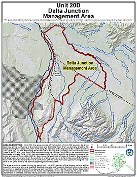
Units: 20D
Area Description: Delta Junction Controlled Use Area: The area consists of that portion of Unit 20(D) bounded by a line beginning at the confluence of Donnelly Creek and the Delta River, then up Donnelly Creek to the Richardson Highway (Mile 238), then north along the east side of the highway to the "12 Mile Crossing Trail" (Mile 252.4), then east along the south side of the "12 Mile Crossing Trail" and across Jarvis Creek to the 33-Mile Loop Road, then northeast along the 33-Mile Loop Road to the intersection with the Alaska Highway (Mile 1414), then southeast along the north side of the Alaska Highway to the bridge at Sawmill Creek (Mile 1403.9), then down the west bank of Sawmill Creek to its confluence with Clearwater Creek and down the south bank of Clearwater Creek to its confluence with the Tanana River, then down the Tanana River to its confluence with the Delta River, and upstream along the east bank of the Delta River to the point of beginning at Donnelly Creek
Restrictions: (B) The area is open to moose hunting by permit only
(C) up to 25 percent of the drawing permits will be issued to applicants who are qualified disabled veterans and qualified disabled active-duty military personnel; an applicant under this subparagraph must
(i) be certified by the United States Department of Veterans Affairs as a recipient of the Purple Heart Medal; and
(ii) be certified by the United States Department of Veterans Affairs as having incurred a 100 percent service-connected disability;