Game Management Unit
(GMU) Information
Unit 19
Note: Use of these maps indicates that you have read and understand the liability statement.
Select a Game Management Unit.
Game Management Unit
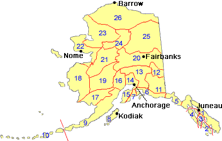
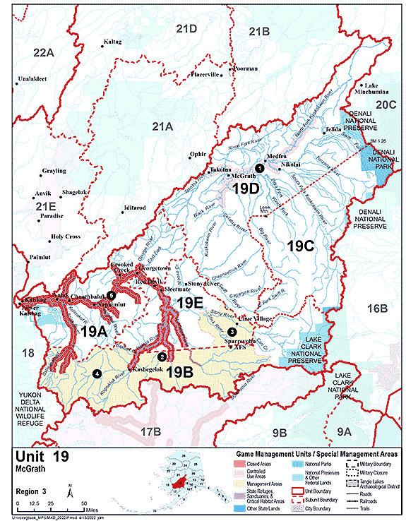
Map of GMU 19
View high-resolution map of Unit 19 (PDF 318 kB)
Boundary Descriptions
GMU 19
Game Management Unit 19 consists of the Kuskokwim River drainage upstream, excluding the drainages of Arhymot Lake, from a line starting at the outlet of Arhymot Lake at Crooked Creek (locally known as Johnson River), then along the south bank of Crooked Creek downstream to the northern terminus of Crooked Creek to the Yukon-Kuskokwim Portage (locally known as the Mud Creek Tramway), then along the west side of the tramway to Mud Creek, then along the westerly bank of Mud Creek downstream to an unnamed slough of the Kuskokwim River (locally known as First Slough or Kalskag Slough), then along the west bank of this unnamed slough downstream to its confluence with the Kuskokwim River, then southeast across the Kuskokwim River to its southerly bank, then along the south bank of the Kuskokwim River upriver to the confluence of a Kuskokwim River slough locally known as Old River, then across Old River to the downriver terminus of the island formed by Old River and the Kuskokwim River, then along the north bank of the main channel of Old River to Igyalleq Creek (Whitefish Creek), then along the south and west bank of Igyalleq Creek to Whitefish Lake, then directly across Whitefish Lake to Ophir Creek then along the west bank of Ophir Creek to its headwaters at 61° 10.22' N. lat., 159° 46.05' W. long.
GMU 19A
Unit 19(A) consists of that portion of Unit 19 in the Kuskokwim River drainage downstream from and including the George River drainage, and downstream from and excluding the Downey Creek drainage
GMU 19B
Unit 19(B) consists of that portion of Unit 19 in the Aniak River drainage upstream from and including the Salmon River drainage, the Holitna River drainage upstream from and including the Bakbuk Creek drainage, that area south of a line from the mouth of Bakbuk Creek to the radar dome at Sparrevohn Air Force Base, including the Hoholitna River drainage upstream from that line, and the Stony River drainage upstream from and including the Can Creek drainage
GMU 19C
Unit 19(C) consists of that portion of Unit 19 south and east of a line from Benchmark M#1.26 (approximately 1.26 miles south of the northwest corner of the original Mt. McKinley National Park boundary) to the peak of Lone Mountain, then due west to Big River, including the Big River drainage upstream from that line, and including the Swift River drainage upstream from and including the North Fork drainage
GMU 19D
Unit 19(D) consists of that portion of Unit 19 in the Kuskokwim River drainage upstream from and including the Swift River drainage, excluding Unit 19(C)
GMU 19E
Unit 19(E) consists of the remainder of Unit 19
Unit 19 Restrictions
Visit the Game Management Unit 19 Restrictions page.
Regulations
View the regulations book entry for GMU 19 (PDF 726 kB)
Access
For land access information see page 8 of the Hunting Regulations.
Contacts
| Region of Alaska | Office Location | Address | Game Management Units |
Phone Number |
|---|---|---|---|---|
| Region 1 - Southeast |
Douglas |
P.O. Box 110024 Juneau AK 99811 |
1–5 | (907) 465-4265 |
| Region 2 - Southcentral |
Anchorage |
333 Raspberry Road Anchorage, AK 99518-1599 |
6–8, 14C, & 15 | (907) 267-2257 |
| Region 3 - Interior |
Fairbanks |
1300 College Road Fairbanks, AK 99701-1551 |
12, 19–21, 24, 25, 26B, & 26C | (907) 459-7206 |
| Region 4 - Central/Southwestern |
Palmer |
1801 S Margaret Drive, Suite 2 Palmer, AK 99645 |
9–11, 13, 14A, 14B, 16, & 17 | (907) 746-6300 |
| Region 5 - Northwest |
Nome |
PO Box 1148 Nome, AK 99762 |
18, 22, 23, & 26A | (907) 443-2271 |