Game Management Unit
(GMU) Information
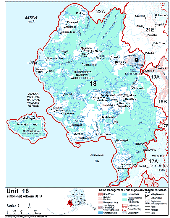
Unit 18
Note: Use of these maps indicates that you have read and understand the liability statement.
Select a Game Management Unit.
Game Management Unit
Map of GMU 18
View high-resolution map of Unit 18 (PDF 272 kB)
Boundary Descriptions
GMU 18
Game Management Unit 18 consists of that area draining into the Yukon and Kuskokwim Rivers westerly and downstream from a line starting at the downriver boundary of Paimiut on the north bank of the Yukon River then south across the Yukon River to the northern terminus of the Paimiut Portage, then south along the Paimiut Portage to its intersection with Arhymot Lake, then south along the northern and western bank of Arhymot Lake to the outlet at Crooked Creek (locally known as Johnson River), then along the south bank of Crooked Creek downstream to the northern terminus of Crooked Creek to the Yukon-Kuskokwim Portage (locally known as the Mud Creek Tramway), then along the west side of the tramway to Mud Creek, then along the westerly bank of Mud Creek downstream to an unnamed slough of the Kuskokwim River (locally known as First Slough or Kalskag Slough), then along the west bank of this unnamed slough downstream to its confluence with the Kuskokwim River, then southeast across the Kuskokwim River to its southerly bank, then along the south bank of the Kuskokwim River upriver to the confluence of a Kuskokwim River slough locally known as Old River, then across Old River to the downriver terminus of the island formed by Old River and the Kuskokwim River, then along the north bank of the main channel of Old River to Igyalleq Creek (Whitefish Creek), then along the south and west bank of Igyalleq Creek to Whitefish Lake, then directly across Whitefish Lake to Ophir Creek, then along the west bank of Ophir Creek to its headwaters at 61° 10.22' N. lat., 159° 46.05' W. long., and the drainages flowing into the Bering Sea from Cape Newenham on the south to and including the Pastolik River drainage on the north; Nunivak, St. Matthews, and adjacent islands between Cape Newenham and the Pastolik River, and all seaward waters and lands within three miles of these coastlines
Unit 18 Restrictions
Visit the Game Management Unit 18 Restrictions page.
Regulations
View the regulations book entry for GMU 18 (PDF 637 kB)
Access
For land access information see page 8 of the Hunting Regulations.
Contacts
| Region of Alaska | Office Location | Address | Game Management Units |
Phone Number |
|---|---|---|---|---|
| Region 1 - Southeast |
Douglas |
P.O. Box 110024 Juneau AK 99811 |
1–5 | (907) 465-4265 |
| Region 2 - Southcentral |
Anchorage |
333 Raspberry Road Anchorage, AK 99518-1599 |
6–8, 14C, & 15 | (907) 267-2257 |
| Region 3 - Interior |
Fairbanks |
1300 College Road Fairbanks, AK 99701-1551 |
12, 19–21, 24, 25, 26B, & 26C | (907) 459-7206 |
| Region 4 - Central/Southwestern |
Palmer |
1801 S Margaret Drive, Suite 2 Palmer, AK 99645 |
9–11, 13, 14A, 14B, 16, & 17 | (907) 746-6300 |
| Region 5 - Northwest |
Nome |
PO Box 1148 Nome, AK 99762 |
18, 22, 23, & 26A | (907) 443-2271 |