Controlled Use Areas
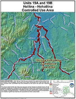
Holitna-Hoholitna Controlled Use Area
Note: Use of these maps indicates that you have read and understand the liability statement.
Units: 19
Area Description: The Holitna-Hoholitna Controlled Use Area: the area consists of the waters of the Holitna River downstream from Kashegelok, the Titnuk River (Creek) downstream from Fuller Mountain and the Hoholitna River downstream from the confluence of the South Fork and main Hoholitna River
Restrictions: The area is closed to the use of any boat equipped with an inboard or outboard motor with an aggregate horsepower in excess of the manufacturer's rating of 40 horsepower for hunting big game, including the transportation of big game hunters, their hunting gear, or parts of big game from August 1 through November 1. However, this provision does not apply to the transportation into the area of game meat that has been processed for human consumption.