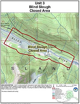
Areas Closed to Hunting
Blind Slough Closed Area
Note: Use of these maps indicates that you have read and understand the liability statement.
Units: 03
Area Description: Unit 3 Blind Slough Closed Area: the area consists of a strip one-fourth mile wide on each side of Blind Slough, from the hunting closure markers at approximately mile 15.1 to the hunting closure markers at approximately mile 18.4 of the Mitkof Highway, including the waters of Blind Slough between those hunting closure markers
Restrictions: Closed to all hunting