Caribou Hunting in Alaska
Hunting Fortymile-White Mountains Caribou
All zones of the Fortymile Caribou hunts are subject to openings and closings on short notice. Call the Fortymile hotline at (907) 267-2310 for information before departing for the field.
Fortymile Caribou Hotline
(907) 267-2310
Fortymile Caribou Zones
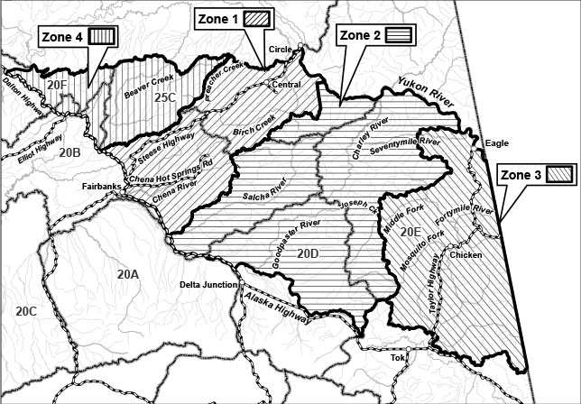
Zone 1
Access in these portions of Units 20B and 25C is generally via Chena Hot Springs Road and the Steese Highway.
The Zone 1 portion of the hunt will be closed by Emergency Order if this zone's harvest quota is reached.
Zone 1 Description
Unit 20B, that portion within the Chatanika River drainage north and east of the Steese Highway, and that portion south and east of the Steese Highway, except the Middle (East) Fork of the Chena River drainage upstream from and including the Teuchet Creek drainage and except the Salcha River drainage.
Unit 25C, that portion east of the east bank of the mainstem of Preacher Creek to its confluence with American Creek, then east of the east bank of American Creek, excluding that portion within the drainage of the south fork of Birch Creek and excluding that portion within the Yukon-Charley Rivers National Preserve.
Zone 2
Access is difficult. Hunters generally fly in or boat up the Goodpaster or Salcha Rivers.
The Zone 2 portion of the hunt will be closed by Emergency Order if this zone's harvest quota is reached.
Zone 2 Description
Unit 20B, that portion south and east of the Steese Highway within the Middle (East) Fork of the Chena River drainage upstream from and including the Teuchet Creek drainage and the Salcha River drainage.
Unit 20D, that portion north of the south bank of the Tanana River.
Unit 20E, that portion within the Charley River drainage, the Seventymile River drainage upstream from and including the Granite Creek drainage, the North Fork Fortymile River drainage upstream from, but not including the Champion Creek drainage, the Middle Fork Fortymile River drainage upstream from and including the Joseph Creek drainage, the Mosquito Fork of the Fortymile River drainage upstream from and including the Wolf Creek drainage, and the drainages flowing into the Yukon River downstream from the confluence of the Seventymile and Yukon Rivers.
Unit 25C, that portion within the drainage of South Fork Birch Creek and that portion within the Yukon-Charley Rivers National Preserve.
Zone 3
Access is generally via the Taylor Highway and the Fortymile River and its tributaries.
The Zone 3 portion of the hunt will be closed by Emergency Order if this zone's harvest quota is reached.
Zone 3 Description
Zone 3; Unit 20E, remainder (the road and trail accessible portion of the herd's range in the vicinity of the Taylor Highway).
Zone 4
Access in these portions of Units 20B, 20F and 25C is generally via the Elliott and Dalton Highways.
The Zone 4 portion of the hunt will be closed by Emergency Order if this zone's harvest quota is reached.
Zone 4 Description
Unit 20B and Unit 20F those portions north and west of the Steese Highway, north and east of the Elliott Highway to its intersection with the Dalton Highway, then east of the Dalton Highway and south of the Yukon River, excluding the Chatanika River drainage.
Unit 25C, that portion west of the east bank of the mainstem of Preacher Creek to its confluence with American Creek, then west of the east bank of American Creek.
Have additional questions?
Please visit the FAQs for Hunting Moose and/or Caribou in Fortymile Country.