Alaska Fish & Wildlife News
June 2013
Introducing ALDAT – The Alaska Lake Database
Are you looking for a place to catch rainbow trout? One that is off the beaten path, has a good camping spot, was recently stocked, or is just minutes from town? There is no better way to find your perfect weekend getaway than to turn to a map. The all new Alaska Lake Database (ALDAT) allows anglers and outdoor enthusiasts to do exactly that from their favorite web browser.
The Alaska Department of Fish and Game (ADF&G) Division of Sport Fish recently completed a new lake database that is accessible to anglers through a Google Earth interface on the department’s website [1]. The database contains contour maps, photographs, fish data, stocking records, and historic documents dating back to the 1950s for over 1,300 water bodies throughout Alaska.
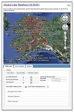
ALDAT has several features that anglers will enjoy. Water bodies are marked on a Google Earth map with colored pins, making stocked fisheries identifiable at a glance. Users can search potential fishing locations by specifying an area, stocking date, or fish species. Do you know where you want to go? Great, use the Go To Location tab to zoom to a specific lake or latitude and longitude. Can’t remember the exact name of the lake? Not a problem, a list of lakes will automatically appear as you begin typing, and many local or previously used names are included in the database. Select a lake from the automated list and the application will take you there. Users can also manually navigate the map using their mouse and overlay useful layers such as roads and trails with a click of a button.
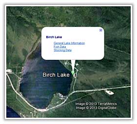
ALDAT contains traditional lake information and more. To view available information, click on a colored pin on the Google Earth map. A pop up balloon will appear with links. Data categories are General Lake Information, Stocking Data, and Fish Data. General Lake Information includes location and access information such as latitude and longitude, directions, and USGS map references; improvements, size, maximum depth, survey notes, photos, contour maps, and historical documents are also listed. Stocking Data includes automated summaries of species previously stocked and offers detailed stocking reports based on the dates you specify (date of release, number, and size of fish). Fish Data includes a summary of fish species captured during previous ADF&G sampling projects (minimum, maximum, and average length).
Not only is ALDAT useful to anglers, but managers, researchers, and students will also find it valuable. The Export Data page allows users to export lake data across multiple datasets directly from the application with the flexibility to specify the fields they wish to include in their request and in what format to export data. Include latitude and longitude in your query and information is ready to be imported into GIS! Additionally, the export data buttons on the Fish Data and Stocking Data pop ups allow you to quickly export the information on your screen directly into Excel.
For anglers accustomed to the old Lake Information and Stocking pages on the ADF&G website, don’t fret. These pages are still available and are now linked to the new ALDAT system. Information is updated automatically as ADF&G continues to populate this dataset.
Looking to explore somewhere new? Try using ALDAT to plan your next fishing trip!
[1] If your computer has never used this application you will be prompted to install a free Google Earth plugin. This plugin is for your internet browser and is different from the Google Earth you may have on your desktop.
Subscribe to be notified about new issues
Receive a monthly notice about new issues and articles.