Destinations
* Indicates historic canoe route access.
- Situk Lake
- Russell Fjord
- Harlequin Lake
- Ahrnklin River
- Situk River
- Strawberry Point *
- Tawah Creek Bridge *
- Tawah Creek at Cannon Bridge *
- Summit Lake *
- Yakutat Bay
- Ankau River/Estuary
- Disenchantment Bay
- Redfield Lakes
Additional Information
Yakutat Wildlife Viewing
Water Trails
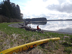
Hundreds of miles of Yakutat area waterways, including rivers, fjords, estuaries, bays, and open waters, may be explored by canoe, kayak, raft, drift boat and motorized skiff. It’s as easy as renting a car, and perhaps a boat, and driving to any of several access points, most of which are relatively close to town. Some people also plan multi-day trips and camp along the way. In some areas, the U.S. Forest Service has cabins available for overnight use.
Some waterways have been used for centuries. The original inhabitants of the area, the Yakutat Kwaan, established a canoe trade route between Yakutat and Dry Bay of which Yakutat to Dry Bay Ancestral Lingit Canoe Route is the official name. A large portion of this historic route is passable between Summit Lake and the Ahrnklin River/Seal Creek estuary. This route may be accessed from several launch sites. Due to changes in topography and the river channels over time, however,travel beyond Ahrnklin River Delta is not recommended
Access to Water Trails
The starting point for the following directions to all destinations—trailheads, boat launches, etc—is the intersection of Forest Highway #10 (FH#10, also called the Dangerous River Road) and Airport Road in Yakutat. Driving distances listed on this site are one-way and approximate.
Yakutat Bay from Sawmill Cove
Directions: Drive 2.5 miles on FH#10 to Sawmill Cove Road (there is no road sign here). Turn left and continue driving 0.7 mile to the cove on Yakutat Bay.
Paddlers can launch a short distance from their vehicle.
Notes for water travelers: This is another great launch site for accessing the inner islands of Yakutat Bay. Sawmill Cove is a excellent vantage point to view Twin Islands and Mt. St. Elias. One day trips are recommended from this access site since leaving a car overnight is not recommended.