Destinations
* Indicates historic canoe route access.
- Situk Lake
- Russell Fjord
- Harlequin Lake
- Ahrnklin River
- Situk River
- Strawberry Point *
- Tawah Creek Bridge *
- Tawah Creek at Cannon Bridge *
- Summit Lake *
- Yakutat Bay
- Ankau River/Estuary
- Disenchantment Bay
- Redfield Lakes
Additional Information
Yakutat Wildlife Viewing
Water Trails
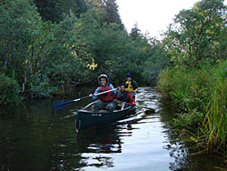
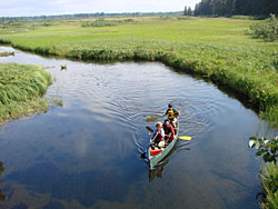
Hundreds of miles of Yakutat area waterways, including rivers, fjords, estuaries, bays, and open waters, may be explored by canoe, kayak, raft, drift boat and motorized skiff. It’s as easy as renting a car, and perhaps a boat, and driving to any of several access points, most of which are relatively close to town. Some people also plan multi-day trips and camp along the way. In some areas, the U.S. Forest Service has cabins available for overnight use.
Some waterways have been used for centuries. The original inhabitants of the area, the Yakutat Kwaan, established a canoe trade route between Yakutat and Dry Bay of which Yakutat to Dry Bay Ancestral Lingit Canoe Route is the official name. A large portion of this historic route is passable between Summit Lake and the Ahrnklin River/Seal Creek estuary. This route may be accessed from several launch sites. Due to changes in topography and the river channels over time, however,travel beyond Ahrnklin River Delta is not recommended
Access to Water Trails
The starting point for the following directions to all destinations—trailheads, boat launches, etc—is the intersection of Forest Highway #10 (FH#10, also called the Dangerous River Road) and Airport Road in Yakutat. Driving distances listed on this site are one-way and approximate.
Tawah Creek at Cannon Bridge
Directions: Drive 2.6 miles on Airport Road to Cannon Beach Road. Turn right and drive 2.1 miles to Cannon Bridge, which crosses over Tawah Creek.
Paddlers can launch boats at the bridge.
Notes for water travelers: Paddlers can go either upstream to Summit Lake or downstream in the direction of Lost River and the Ahrnklin/Situk Estuary. Boaters can end the trip in several places downstream—which will require a car shuttle or pick up—or simply paddle back to Cannon Bridge. During summer low water periods, some sections will be slow and weedy, particularly between Summit Lake and Cannon Beach Bridge. Portages are often required near the outwash of Summit Lake due to fallen trees and beaver activity. Consult tide books; it is easiest to travel upstream on Lost River on in-coming tide. You will be required to portage past remnants of an old bridge between Cannon Bridge and Tawah Creek Bridge, and multiple small portages are required further downstream due to logs across lower Tawah Creek.