Destinations
* Indicates historic canoe route access.
- Situk Lake
- Russell Fjord
- Harlequin Lake
- Ahrnklin River
- Situk River
- Strawberry Point *
- Tawah Creek Bridge *
- Tawah Creek at Cannon Bridge *
- Summit Lake *
- Yakutat Bay
- Ankau River/Estuary
- Disenchantment Bay
- Redfield Lakes
Additional Information
Yakutat Wildlife Viewing
Water Trails
Hundreds of miles of Yakutat area waterways, including rivers, fjords, estuaries, bays, and open waters, may be explored by canoe, kayak, raft, drift boat and motorized skiff. It’s as easy as renting a car, and perhaps a boat, and driving to any of several access points, most of which are relatively close to town. Some people also plan multi-day trips and camp along the way. In some areas, the U.S. Forest Service has cabins available for overnight use.
Some waterways have been used for centuries. The original inhabitants of the area, the Yakutat Kwaan, established a canoe trade route between Yakutat and Dry Bay of which Yakutat to Dry Bay Ancestral Lingit Canoe Route is the official name. A large portion of this historic route is passable between Summit Lake and the Ahrnklin River/Seal Creek estuary. This route may be accessed from several launch sites. Due to changes in topography and the river channels over time, however,travel beyond Ahrnklin River Delta is not recommended
Access to Water Trails
The starting point for the following directions to all destinations—trailheads, boat launches, etc—is the intersection of Forest Highway #10 (FH#10, also called the Dangerous River Road) and Airport Road in Yakutat. Driving distances listed on this site are one-way and approximate.
Disenchantment Bay
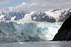
Directions: A short flight by bush plane or charter boat is required to access Disenchantment Bay at Esker Creek on the west side of the bay.
Paddlers can launch on the shoreline of Disenchantment Bay at Esker Creek.
Notes for water Travelers: Esker Creek and Point Latouche mark the approximate southern boundary of Disenchantment Bay. Esker Creek lies within the National Preserve of Wrangel-St.Elias National Park. A well-insulated cabin—the Esker Stream Public Use Cabin—is available for public use; call the National Park Service at (907) 784-3295 for more information. Traveling north will give paddlers fabulous views of the Hubbard Glacier and Haenke (Egg) Island. Hiking to Bancas Point for land views of the bay is an option. At times, shore ice and flooding will restrict access to Esker Creek.