Ice Seal Tracking Maps Archive
06/179/2016 – 07/193/2016
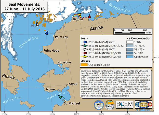
We are pleased to announce that two bearded seals and one ringed seal were recently tagged near St. Michael by trained hunter-taggers. Alexander Niksik worked with Palsson Fitka to capture and tag a ringed seal (RS16-01-M) on 10 June and with Palsson Fitka and Stephan Horn Jr. to capture and tag two bearded seals (BS16-01-M and BS16-02-M) on 3 and 4 July near St. Michael. We would also like to congratulate the North Slope Borough Department of Wildlife Management (NSB-DWM) for deploying tags on 12 ringed seals earlier this month. Two of the ringed seals they tagged (RS16-02-M and RS16-07-M) were tagged with transmitters (CTDs manufactured by the Seal Mammal Research Unit, University of St. Andrews, UK) we provided to NSB-DWM as part of a collaborative project. Therefore, movements made by these two seals will be reported on maps prepared by both ADF&G and NSB-DWM.
During the last fourteen days we have received locations for 2 bearded seals and 3 ringed seals. Bearded seal BS15-07-M (blue line) is still moving north in the eastern Chukchi Sea. The second bearded seal, BS16-01-M (green line), has moved from its tagging location near St. Michael to central Norton Sound. The other bearded seal tagged near St. Michael (BS16-02-M) was tagged with a SPOT tag (Wildlife Computers, Redmond, WA) attached to one of its hind flippers. Because tags only transmit locations when they are out of the water and the SPOT tag is attached to the seal's flipper, this tag will only send locations when the seal is hauled out on sea ice or land. This seal has not hauled out of the water yet. As such, we have not received any locations for BS16-02-M. As for the ringed seals, RS16-01-M (gray line) also was only tagged with a SPOT tag on one of its hind flippers. Since being tagged near St. Michael on 10 June we have only received two locations for this ringed seal when it hauled out on ice in the central Chukchi Sea on 1 July. The two ringed seals tagged with CTD tags by NSB-DWM (RS16-02-M, red line; and RS16-07-M, yellow line) have moved east of their tagging locations near Barrow, generally following the coastline. No clear satellite images were available from the NASA Rapid Response Network because of thick cloud cover this week. Therefore, I used sea ice data courtesy of the University of Bremen, Germany, and dated 11 July (http://www.iup.uni-bremen.de:8084/amsr2/).
During the last fourteen days we have received locations for 2 bearded seals and 3 ringed seals. Bearded seal BS15-07-M (blue line) is still moving north in the eastern Chukchi Sea. The second bearded seal, BS16-01-M (green line), has moved from its tagging location near St. Michael to central Norton Sound. The other bearded seal tagged near St. Michael (BS16-02-M) was tagged with a SPOT tag (Wildlife Computers, Redmond, WA) attached to one of its hind flippers. Because tags only transmit locations when they are out of the water and the SPOT tag is attached to the seal's flipper, this tag will only send locations when the seal is hauled out on sea ice or land. This seal has not hauled out of the water yet. As such, we have not received any locations for BS16-02-M. As for the ringed seals, RS16-01-M (gray line) also was only tagged with a SPOT tag on one of its hind flippers. Since being tagged near St. Michael on 10 June we have only received two locations for this ringed seal when it hauled out on ice in the central Chukchi Sea on 1 July. The two ringed seals tagged with CTD tags by NSB-DWM (RS16-02-M, red line; and RS16-07-M, yellow line) have moved east of their tagging locations near Barrow, generally following the coastline. No clear satellite images were available from the NASA Rapid Response Network because of thick cloud cover this week. Therefore, I used sea ice data courtesy of the University of Bremen, Germany, and dated 11 July (http://www.iup.uni-bremen.de:8084/amsr2/).