Hunter Access
Completed Projects
Maud Road Extension & the Knik River Public Use Area
Coordinates: 61.584917, -148.988000
Game Management Unit: 14A
Land Manager: Department of Natural Resources (DNR); Division of Mining, Land, and Water
The Knik River Public Use Area (KRPUA) provides a variety of recreation opportunities. The most heavily used route into this area is the Maud Road Extension, a minimally maintained gravel road that begins at the termination of Maud Road. The Maud Road Extension, which ends at Jim Lake, provides access to trailheads, sprawling lakes, wetland habitat, and a shooting range, making this area popular among birders, boaters, anglers, hunters, and shooters. Hunting opportunities include moose, sheep, black and brown bear, waterfowl, and other small game.
Prior to this project, the road surface had been worn down through heavy use and unmaintained runoff. Pre-existing culverts had also filled with sediment and gravel, limiting fish passage. The parking and lake access area near Jim Lake was also in poor condition and was inadequate in size to serve as a turnaround for vehicles with trailers.
Purpose
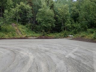
The project's objective was to improve access to the KRPUA along the Maud Road Extension by repairing and resurfacing the road and improving drainage through the addition of culverts and ditching, as necessary. Improved parking near Jim Lake was also an objective.
Outcome
Drainage and road surface issues were corrected through the addition of more than 20 culverts and six inches of fill material to the roadbed, which was also re-graded. A vehicle parking and turnaround area was created at the Jim Lake terminus of the Maud Road Extension, while the nearby trailhead parking for Rippy Trail was also improved.
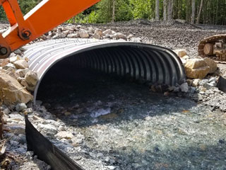
Habitat restoration took place in damaged areas surrounding the road surface, including the installation of an improved culvert for McRoberts Creek to ensure fish passage.
Project Partner
Maud Road Extension Location (KRPUA Access) *
*The Maud Road Extension crosses Eklutna Inc. land within a 60-foot wide 17(b) easement (77 D,L,M) to access state land within the KRPUA. The allowed uses within the easement are travel by foot, dogsleds, animals, snowmobiles, two- and three-wheel vehicles, small and large all-terrain vehicles (ATVs), tracked vehicles, four-wheel-drive vehicles, automobiles, and trucks.