
Lower Kenai Controlled Use Area
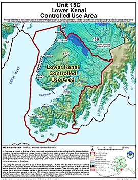
Units: 15C
Area Description: The Lower Kenai Controlled Use Area: that portion of Unit 15C north of Kachemak Bay, Kachemak Creek, Bradley River, and Bradley Lake
Restrictions: A. The area is closed to the use of any motorized vehicle (except an aircraft or boat) for big game hunting, including the transportation of big game hunters, their hunting gear, or parts of big game from September 16 through September 19 and September 22 through September 25; however, this provision does not apply to the use of a motorized vehicle on a platted and improved (graveled, asphalted, or paved) borough, state, or municipal roads, or driveways used for direct access to a primary residence or business
B. During the periods specified in (ii) of this subparagraph, a hunter who travels by motorized vehicle on the Unit 15(C) highway system and then leaves and travels off that highway system in that motorized vehicle may not hunt big game, including transporting big game hunters, their hunting gear, or parts of big game, or in any other manner initiate or participate in big game hunting activities, until after the hunter returns the motorized vehicle to the Unit 15(C) highway system; upon returning the motorized vehicle to that highway system, the hunter may initiate or participate in legal big game hunting activities so long as the hunter leaves the motorized vehicle on the Unit 15(C) highway system
;