Kachemak Bay Personal Use Gillnet Fishery
Permits & Regulations
To participate in any personal use fishery, you must be an Alaska Resident, and possess a valid Sport Fishing License or ADF&G senior license or ADF&G Disabled Veteran's License.
A permit is required to personal use gillnet in Kachemak Bay.
Kachemak Bay coho set gillnet permits can be obtained from the Homer ADF&G office, 3298 Douglas Place, voice (907) 235-8191, fax (907) 235-2448.
Households may not have both the Upper Cook Inlet Personal Use Salmon Permit and the Kachemak Bay Coho Salmon Set Gillnet Permit. Households must choose one or the other permit.
Personal use permits are household permits. This means that only one permit is required per household. However, all participating members of the household who are 18 years old or older must also have an Alaska resident sport fishing license, ADF&G senior license or ADF&G Disabled Veteran's license to participate, and must be named on the permit.
Permits must be filled in each time you fish
You must record the date, location, and harvest by species each time you fish. You must fill in this information even if you did not catch any fish—write "0" in the space provided for harvest.
The salmon must be recorded on the permit before it is concealed from plain view, such as put in a cooler, or before the salmon is transported from the fishing site, such as your vehicle. Failure to record the salmon on the permit is a violation, and may be subject to fines and loss of future personal use fishing privileges.
Permits must be returned to ADF&G
Each household permit is also a harvest recording document. You must return your permit to the Homer office at the end of the fishing season, by the date specified on the permit, even if you did not use the permit, and even if you did use the permit but did not catch anything.
Failure to return the permit is a violation of 5 AAC 77.015(c) and may be subject to a $200 fine and loss of your personal use fishing privileges.
Bag limits
Bag limits for the Kachemak Bay Coho Set Gillnet fishery are also 25 for the permit holder plus 10 for each additional household member.
These are annual household limits, not a daily limit, or a limit per fishery.
Personal use salmon required to be "marked"
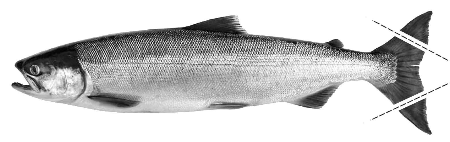
By regulation, you must "mark" salmon harvested in a personal use fishery in which a permit is required by clipping both tips of the tail fin. Scissors or shears are the best way to cut off the tips of the tail fin.
The salmon must be marked before the salmon is concealed from plain view, such as put in a cooler, or before the salmon is transported from the fishing site, such as your vehicle. Failure to mark the salmon is a violation, and may be subject to fines and loss of future personal use fishing privileges.
Open season
Under 5 AAC 77.549 "Personal Use Coho Salmon Fishery Management Plan," the fishery begins at 6:00 a.m. on the first Monday or Thursday following August 15, and ends the last Wednesday or Saturday before September 16 and only from 6:00 a.m. Monday until 6:00 a.m. Wednesday and from 6:00 a.m. Thursday until 6:00 a.m. Saturday.
All nets must be totally removed from the water during closed periods (i.e., BY 6:00 a.m.).
The fishery closes by Emergency Order when the guideline harvest range (GHR) of 1,000 to 2,000 coho salmon has been taken. The fishery could be closed prior to obtaining the GHR if the Department determines that continuation of the fishery could negatively impact wild stocks of coho.
Those who participate in this fishery are asked to call in their daily catches to the Homer ADF&G office at (907) 235-8191 during the open season.
Gear
The following requirements for the Kachemak Bay personal use set gillnetting are in addition to the regular requirements of a set gillnet.
- No set gillnet may exceed 35 fathoms in length, six inches in mesh size, and 45 meshes in depth.
- No part of a set gillnet may be operated within 600 feet of another set gillnet.
- No person may operate more than one set gillnet.
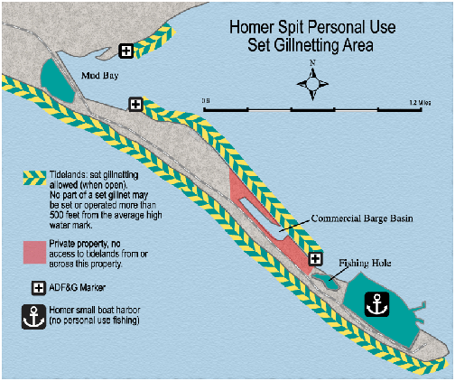
- No part of a set gillnet may be set or operated more than 500 feet from the mean high water mark.
- No set gillnet may be set seaward of another set gillnet.
All fishers are advised to look for signs designating private property. It is the responsibility of each individual participating in the personal use fishery to determine private property boundaries, even if the land is not posted. Please respect the rights of property owners and avoid trespassing on private lands.
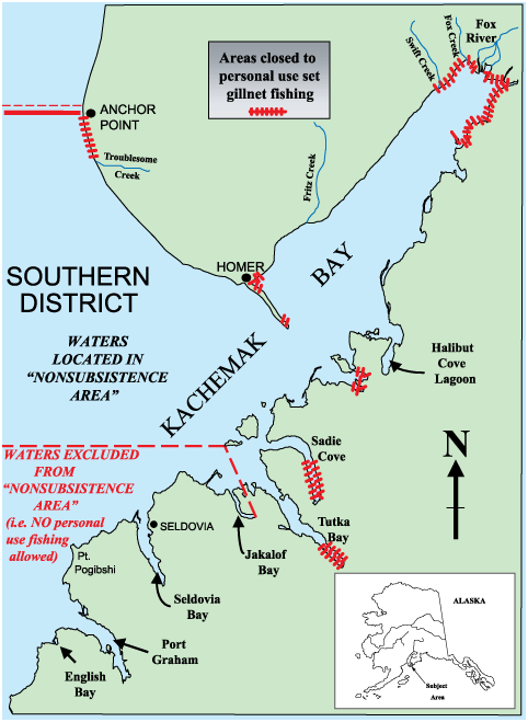
Area Open
The area of the Southern District open to personal use fishing is comprised of waters described as "nonsubsistence", which include those waters east of a line from the easternmost point of Jackalof Bay north to the westernmost point of Hesketh Island, and north of the latitude of the westernmost point of Hesketh Island, except for the closed areas described below.
Salmon may not be taken in the following waters:
- Northeast of a line from an ADF&G marker at 59° 44.5' N. latitude, 151° 02.01' W. longitude [a point on the mainland near Chugachik Island], to an ADF&G marker on the shore one-half statute mile southwest of the terminus of Swift Creek (or 59° 47.15' N. latitude, 151° 05.45' W. longitude); and
- Waters of China Poot Bay south and east of the Homer Electric Association power line; and
- Waters of Sadie Cove south of 59° 30.0' N. latitude; and
- Waters of Tutka Bay Lagoon; and
- Tutka southeast of 59° 25.50' N. latitude; and
- Any bay, estuary, slough or lagoon less than 300 feet in width at mean low tide; and
- In all other streams or rivers within 500 yards of the terminus (or as posted); and
- Between the terminus of Troublesome Creek and the terminus of the Anchor River; and
- From the north entrance of the Homer Boat Harbor, northwest along [the east side of] the Home Spit to a department marker located approximately 200 yards northwest of the entrance to the Homer Spit Fishing Hole; and
- West of a line from an ADF&G marker at "Green Timbers"59° 37.09' N. latitude, 151° 28.07' W. longitude) on the Homer Spit to an ADF&G marker approximately 300 yards east of the Homer Airport access road (approximately 59° 38.35' N. latitude, 151° 28.62' W. longitude).