Kanuti Controlled Use Area
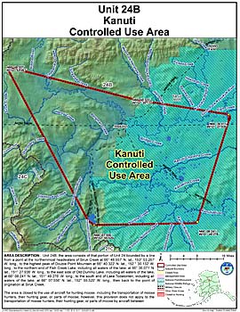
Units: 24
Area Description: Kanuti Controlled Use Area: the area consists of that portion of Unit 24B bounded by a line from a point at the northern most headwaters of Siruk Creek at 66° 48.557’ N. lat. 153° 53.267’ W. long., to the highest peak of Double Point Mountain at 66° 40.322’ N. lat. 152° 30.132’ W. long., to the northern end of Fish Creek Lake (including all water of the lake) at 66° 36.071’ N. lat. 151° 27.936’ W. long., to the east side of Old Dummy Lake (including all waters of the lake) at 66° 08.241’ N. lat. 151° 49.276’ W. long., to the south end of Lake Todatonten (including all waters of the lake) at 66° 07.556’ N. lat. 152° 55.520’ W. long., then back to the point of origination at Siruk Creek.
Restrictions: The area is closed to the use of aircraft for hunting moose, including transportation of moose hunters, their gear, and/or parts of moose. However, this prohibition does not apply to the transportation into the area of game meat that has been processed for human consumption.