Delta Controlled Use Area
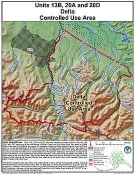
Units: 13B, 20A, 20D
Area Description: Units 13 and 20; the area consists of those portions of Units 13(B), 20(A), and 20(D) beginning at the confluence of Miller Creek and the Delta River then west to VABM Miller, then west to include all drainages of Augustana Creek and Black Rapids Glacier, then north and east to include all drainages of McGinnis Creek to its confluence with the Delta River, then east in a straight line across the Delta River to the east bank of the Delta River, then north along the east bank to a point opposite the intersection of the Alaska and Richardson Highways, then east in a straight line to the intersection of the Alaska and Richardson Highways, then east along the Alaska Highway to the west bank of the Johnson River, then south along the west bank of the Johnson River and Johnson Glacier to the head of the Canwell Glacier, then west along the north bank of the Canwell Glacier and Miller Creek to the Delta River
Restrictions: Closed to the use of any motorized vehicle or pack animal for big game hunting, including the transportation of big game hunters, their hunting gear, or parts of big game from August 5 through August 25; however, this provision does not prohibit motorized access, or transportation of game, on the Richardson Highway, or the use of aircraft to and from the Charlie Boyd airstrip (63° 29' 30N. lat., 144° 50' 45"W. long.) along the Johnson River