Fish Count Data Search
|
Location: Russian River |
The selected years are color-coded in the graphs below:
|
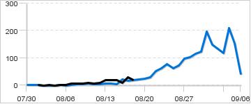
Daily Counts
|
Cumulative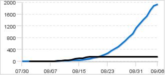
|
|
Description: The weir is located at the outlet of Lower Russian Lake, about 78 miles from the mouth of the Kenai River. It takes approximately 7 to 10 days for sockeye salmon to travel from the lower Kenai River to the weir depending on water levels. Travel times are estimates and can vary significantly from this depending on conditions. The current weir-based early-run sockeye salmon sustainable escapement goal (SEG) is 22,000-44,000 and was adopted in 2011. The late-run sockeye salmon stock was managed to achieve an SEG of 30,000-110,000 (years 2005-2019). In 2020, the new SEG range was adopted for the late-run Russian River sockeye salmon and is now 44,000-85,000.
Biological Escapement Goal for Sockeye - Early Run:
22,000 - 42,000
|
|
|
Contact:
Northern Kenai Sport Fish Assistant Area Manager, | |
39 records returned for the years selected. Dashes indicate days with no count.
[Export results in Excel format or JSON format]
| Date 2019 |
Count 2019 |
Cumulative 2019 |
Cumulative 2018 |
Notes for 2019 |
|---|---|---|---|---|
| Sep-06 | - | 162 | 1,936 | |
| Sep-05 | - | 162 | 1,897 | |
| Sep-04 | - | 162 | 1,744 | |
| Sep-03 | - | 162 | 1,534 | |
| Sep-02 | - | 162 | 1,417 | |
| Sep-01 | - | 162 | 1,284 | |
| Aug-31 | - | 162 | 1,136 | |
| Aug-30 | - | 162 | 939 | |
| Aug-29 | - | 162 | 816 | |
| Aug-28 | - | 162 | 701 | |
| Aug-27 | - | 162 | 598 | |
| Aug-26 | - | 162 | 501 | |
| Aug-25 | - | 162 | 428 | |
| Aug-24 | - | 162 | 365 | |
| Aug-23 | - | 162 | 287 | |
| Aug-22 | - | 162 | 225 | |
| Aug-21 | - | 162 | 174 | |
| Aug-20 | - | 162 | 145 | |
| Aug-19 | - | 162 | 122 | |
| Aug-18 | 18 | 162 | 101 | Water level 6.38"; weir evacuated due to fire activity; incomplete count |
| Aug-17 | 29 | 144 | 83 | Water level 6.5" |
| Aug-16 | 9 | 115 | 66 | Water level 6.5" |
| Aug-15 | 20 | 106 | 45 | Water level 6.75" |
| Aug-14 | 19 | 86 | 41 | Water level 6.75" |
| Aug-13 | 19 | 67 | 34 | Water level 6.75" |
| Aug-12 | 8 | 48 | 27 | Water level 6.88" |
| Aug-11 | 7 | 40 | 24 | Water level 7" |
| Aug-10 | 10 | 33 | 20 | Water level 7.13" |
| Aug-09 | 7 | 23 | 14 | Wayer level 7.25" |
| Aug-08 | 6 | 16 | 10 | Water level 7.38" |
| Aug-07 | 6 | 10 | 7 | Water level 7.5" |
| Aug-06 | 1 | 4 | 6 | Water level 7.63" |
| Aug-05 | 1 | 3 | 6 | Water level 7.75" |
| Aug-04 | 0 | 2 | 4 | Water level 7.88" |
| Aug-03 | 1 | 2 | 4 | Water level 8" |
| Aug-02 | 0 | 1 | 4 | Water level 8" |
| Aug-01 | 1 | 1 | 4 | Water level 8.25" |
| Jul-31 | - | - | 3 | |
| Jul-30 | - | - | 1 |