Introduction to the Anadromous Waters Catalog
Anadromous Waters Catalog and Atlas Users’ Guide
Format
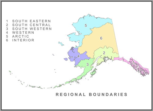
The Atlas and Catalog are divided into six volumes corresponding to Alaska’s six fish and game resource management regions (Arctic, Interior, Western, Southwestern, Southcentral, Southeastern) established in 1982 by the Joint Boards of Fisheries and Game (see Figure 1). A figure on the front cover of each Catalog and Atlas shows the geographic area covered in that volume.
The Catalog is a numerical listing of the water bodies documented as being used by anadromous fish. Also listed are the U.S. Geological Survey (USGS) quadrangle (quad) map, latitude, longitude, anadromous fish documented in the water body and a legal description for the mouth and upper known extent of anadromous fish use for each specified water body.
The Atlas to the Catalog is a compilation of topographic maps that cartographically shows the location, name, and number of these specified anadromous fish-bearing water bodies, the anadromous fish species using these water bodies, and the fish life history phases for which the water bodies are used (to the extent known).
Limitations
Location information (latitude/longitudes, legal descriptions) and graphic representations used in the Atlas and Catalog are primarily derived from USGS quad maps, from field observations, and in some cases from aerial photos. ADF&G use the most recent editions of these quad maps, when possible, to depict as accurately as possible the locations of water bodies found in the Atlas and Catalog. The intent is to avoid any confusion when referring to a specific water body. In some parts of Alaska, however, channel and coastline configurations have changed since the relevant USGS quad map was published, making it not entirely accurate for on-the-ground use. Locations listed in the catalog should be compared to the water body locations depicted on Atlas maps, not to field-surveyed or photo-extracted locations.
In some instances, polygons are used to specify areas containing a number of water bodies supporting anadromous fish that are impossible to depict legibly and accurately on 1:63,360-scale maps. Generally used by juvenile anadromous fish for rearing, water bodies in these polygons are highly productive and are considered important for anadromous fishes.
Fisheries surveys are important tools protecting anadromous fish habitat, and for managing sport, personal use, subsistence and commercial fisheries. Data are collected by various methods including aircraft, boat, and foot. Due to timing, water clarity, temperature, survey method or other factors, a survey for a particular species may fail to gather complete life-phase information, or observe juvenile fish, non-targeted anadromous fish species, or the actual upper limit of anadromous fish use. Therefore, the upper points of stream reaches listed in the Catalog and shown in the Atlas usually reflect the extent of fish surveys or known anadromous fish use in a particular water body rather than the actual limits of anadromous fish occurrence or of habitat use.
In addition, only a limited number of the water bodies in Alaska have actually been surveyed. Virtually all coastal water bodies in the state provide important habitat for anadromous fish, as do many unsurveyed tributaries to known anadromous fish-bearing water bodies. Anadromous fish often rear in small tributaries, flood channels, intermittent streams, and beaver ponds. Due to the remote location, small size, or ephemeral nature of these systems, most have not been surveyed and are not included in the Catalog or Atlas.
Figure 1. Atlas and Catalog Regional Boundaries