Introduction to the Anadromous Waters Catalog
Interpretation of the Atlas
Alaska is depicted by 153 1:250,000-scale USGS quadrangles (see Figure 2). Most quadrangles of this scale are further divided into 1:63,360-scale inch-to-the-mile maps (also known as quadrangles). The Atlas contains the 1:250,000-scale quadrangles to help users locate anadromous water body information on the more detailed 1:63,360-scale map(s), if any exist for an area. Where inch-to-the-mile USGS maps do not yet exist (e.g., in parts of the Interior, Arctic, Western, and Southwest regions), specified water bodies are drawn at 1:63,360-scale (inch-to-the-mile) using the 1:250,000-scale quadrangles as the base maps.
Numbering of Specified Waters
Note: Examples given below refer to Figure 3.
All streams, rivers, and lakes specified in the Atlas and Catalog have a unique identifying number. The first six elements consist of a three-digit number and a two-digit number, separated by a hyphen. By convention, this number set is derived from the 1982 ADF&G statistical fishing district number which identifies the body of salt water to which the system drains. In order to maintain a unique number for each specified water body through time the numbering system in the Atlas and Catalog remains based on the original 1982 statistical area boundaries, although fish district numbers change periodically.
Rivers or streams which flow directly into salt water are identified by a five-digit suffix added to the fishing district number. For each main channel river or stream, this suffix begins with the number 1. For example, Big River (at the top of Figure 3) is “101-52-10100” (where “101-52” identifies the statistical fishing district and “10100” is a main channel water body in that district).
A stream branching from a main channel water body (tributary) carries the same base number (e.g., 101-52-10100) plus a four-digit number indicating that specific tributary. By convention, the last digit of a number sequence used to identify tributary streams will be even if the tributary branches to the right (heading upstream) and odd if it branches to the left. In the example, provided, “2021” denotes the tributary that branches to the left (heading upstream) on Big River, making the entire number for this tributary stream 101-52-10100-2021. Succeeding tributary streams are numbered in the same way by adding a four-digit number for each branch. The first digit for each branch sequence always indicates the progression of tributary stream numbering from the main channel.
Because of limited space on maps, often only the number sequence of a specific tributary appears next to that tributary; however, the entire number sequence down to the statistical fishing district number can be determined by following the water body downstream. The Catalog lists the entire water body number.
The number assigned to a lake begins with the number of the stream that drains from it, plus a four-digit number beginning with a zero. In Figure 3, a lake occurs along a tributary stream in the Blue Creek drainage. Therefore, the unique identification number first designates the tributary stream number (101-53-10100-2010-3005), followed by the four-digit lake identifier (0010), resulting in the full designation (101-53-10100-2010-3005-0010).
Figure 2. 1:250,000 scale quad names and numbers
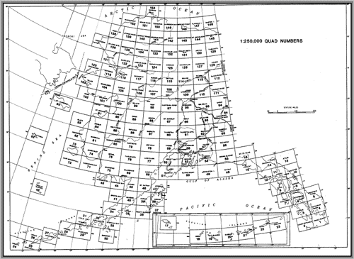
Figure 3. Examples of Map Stream numbering
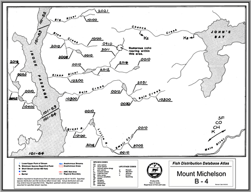
Used only in special cases, polygons will be numbered, whenever possible, with the stream number on which the polygon is located This number is then followed by a four-digit number sequence beginning with 09 to designate the polygon. In the example, a polygon adjoins a tributary to the Kleen River. The polygon’s unique identification number would be 101-53-10200-2016-3011- 0910, the stream number (101-53-10200-2016-3011) plus the polygon designator “0910.”
Figure 3 shows four watersheds having multiple lakes and flowing to Inoue Passage. Each illustrates a different aspect of the water body numbering system.
- The main channel is named “Kleen River,” but the named river does not continue above the first lake. Kleen River is numbered 101-53-10200, (101-53 for statistical fishing district “101-53” followed by the main channel river). A lake identifier “0010” is then added to denote the first lake upstream of Kleen River. All tributaries flowing into a lake retain the base number of the lake’s outlet stream but add a next-higher-tributary stream identifier. The tributary to the first lake above Kleen River is therefore numbered 101-53-10200-2012. A headwater lake that drains into a tributary reflects that sequence in its last two suffixes: 101- 53-10200-2016-0010 with -2016 identifying the tributary stream and -0010 designating the lake. Any streams flowing into this lake would be tributary streams and numbered accordingly.
- A multi-lake example, Rain Creek passes through a series of lakes. Each lake is assigned the main channel number 101-53-10300, followed by a sequential and unique lake number, 0010 for the first lake, and 0020 for the second. Tributaries to either Rain Creek or the lakes (none shown) would bear a tributary stream number after the base number.
- The same numbering conventions apply to a system with unnamed streams (see left side of Inoue Passage). Each lake is numbered from the main channel, with an added lake number (101-53-10400-0010, for the first lake, and 101-53-10400-0020 for the second lake).
- In the final example, Great River, Little River, and Small Creek are tributary streams. Each named stream is separated by a lake, to which it is a tributary. The lake above each tributary has the same number as its outlet stream but with an added lake identifier. The first lake (above stream Great River) is 101-54-10100-0010; the second lake (above the next tributary named Little River) is 101-54-10100-2014-0010; and the third lake (above the next tributary named Small Creek) is 101-54-10100-2014-3005-0010. Alone, the lake identifiers for these three lakes appear to be the same; however, when combined with the outlet stream number, a unique number for each stream is formed.
Symbols
The alphanumeric map number in the lower left corner of the maps identifies the 1:63,360-scale quadrangle of the 1:250,000-scale quadrangle (Numbers for the 1:250,000-scale quadrangles are identified on Figure 3). The legend beneath each map lists letter symbols for each fish species and life activity. Some maps also include the symbol (★) to depict streams for which the length of documented fish habitat is too short (less than 660 feet) to accurately map at the 1:63,360-scale. In most cases, barriers to fish passage or limits of fish survey efforts account for the short terminus. Locations where barriers are known to exist are denoted by the (![]() ) symbol.
) symbol.
Arrows on the maps delineate the distribution of fish in a water body, where known. A single arrow drawn at the mouth of a stream or stream reach shows which fish species migrate upstream. Downstream-pointing arrows farther upstream indicate the highest point at which a fish species is currently known to occur (see symbols for king salmon spawning on Chance Creek, Figure 3).
The anadromous waters number and species string is used to indicate the range of anadromous fish species that continues onto adjacent Atlas maps.