Fish Passage Site 20401304
Coordinates (dec. deg.): 61.56313°, -149.45046°
Legal Description: S017N001W16
Region: South Central
Road Name: Fern
Datum: NAD83
Quad Name / ITM: Anchorage C-7
AWC Stream #: 247-50-10300
Stream Name: Cottonwood Creek
Elevation:
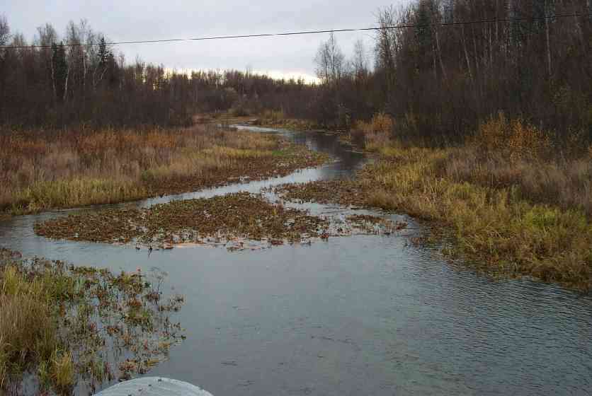
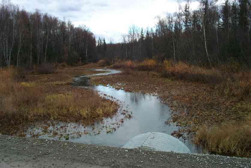
Site Comments: Ponded above & below (aquatic & wetland)
arrow to the right of the survey date below to choose a different report for this site.
Survey MSCS1-CT155
Observers: Edward Weiss, Joe Conner, Nathan Pannkuk
Overall Fish Passage Rating:
Tidal: No
Backwatered: No
Step Pools:
Construction Year:
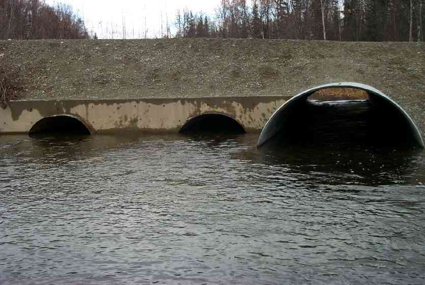
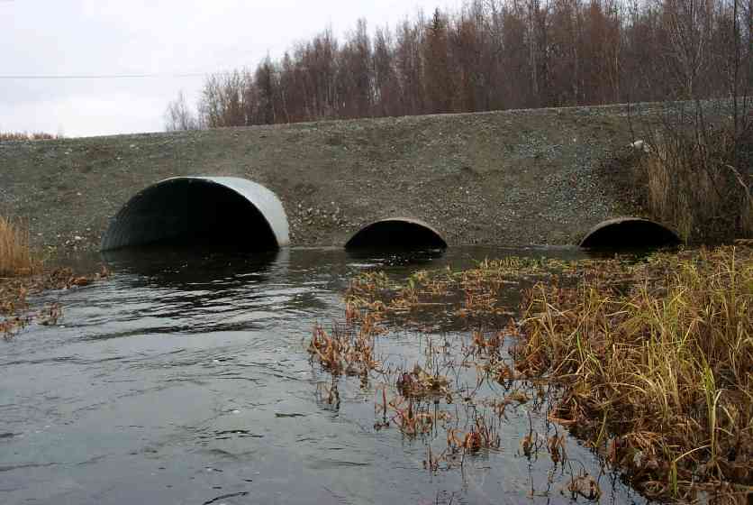
Comments: Ponded above and below Ponded above & below (aquatic & wetland) - bankful 109' wide; center & right culverts 1/2 full of substrate; F/CG/S in channel;S & Silt in area of aquatics;channel thru aquatic veg;concrete headwall
Culvert Measurements
| ID: 1 | Structure Type: Open-bottom arch (Strutural Metal Plate) | Fish Passage Rating: | |||||||||||||||||||||||||||||||||||||||||
|
|
|
|||||||||||||||||||||||||||||||||||||||||
Culvert Observations:
|
|||||||||||||||||||||||||||||||||||||||||||
| ID: 2 | Structure Type: Open-bottom arch (Strutural Metal Plate) | Fish Passage Rating: | |||||||||||||||||||||||||||||||||||||||||
|
|
|
|||||||||||||||||||||||||||||||||||||||||
Culvert Observations:
|
|||||||||||||||||||||||||||||||||||||||||||
| ID: 3 | Structure Type: Open-bottom arch (Strutural Metal Plate) | Fish Passage Rating: | |||||||||||||||||||||||||||||||||||||||||
|
|
|
|||||||||||||||||||||||||||||||||||||||||
Culvert Observations:
|
|||||||||||||||||||||||||||||||||||||||||||
Stream Measurements
|
|
No stream width data available.
Elevations
| Locator ID | Culvert Number |
River Distance (ft)1 |
Distance From Crossing (ft)2 |
Relative Elevation (ft) |
|---|---|---|---|---|
| Inlet Culvert Top | 3 | 91.20 | ||
| Outlet Culvert Top | 2 | 91.25 | ||
| Outlet Culvert Top | 3 | 91.28 | ||
| Inlet Culvert Top | 2 | 91.33 | ||
| Outlet Culvert Top | 1 | 93.13 | ||
| Inlet Culvert Top | 1 | 93.29 | ||
| D/S Thalweg | 0.00 | 44.0 | 88.07 | |
| Outlet Invert | 1 | 44.00 | 0.0 | 88.44 |
| Outlet Thalweg | 1 | 44.00 | 0.0 | 88.44 |
| Outlet Invert | 3 | 44.00 | 0.0 | 88.93 |
| Outlet Thalweg | 3 | 44.00 | 0.0 | 88.93 |
| Outlet Invert | 2 | 44.00 | 0.0 | 89.17 |
| Outlet Thalweg | 2 | 44.00 | 0.0 | 89.17 |
| Road Elev | 65.00 | 96.02 | ||
| Road Elev | 65.00 | 96.18 | ||
| Inlet Culvert Invert | 1 | 86.00 | 0.0 | 89.04 |
| Inlet Thalweg | 1 | 86.00 | 0.0 | 89.04 |
| Inlet Culvert Invert | 3 | 86.00 | 0.0 | 89.33 |
| Inlet Thalweg | 3 | 86.00 | 0.0 | 89.33 |
| Inlet Culvert Invert | 2 | 86.00 | 0.0 | 89.42 |
| Inlet Thalweg | 2 | 86.00 | 0.0 | 89.42 |
| U/S Thalweg | 1 | 91.00 | 5.0 | 88.73 |
| U/S Thalweg | 3 | 91.00 | 5.0 | 88.84 |
| U/S Thalweg | 2 | 91.00 | 5.0 | 89.14 |
| U/S Thalweg | 111.00 | 25.0 | 88.41 | |
| U/S Thalweg | 136.00 | 50.0 | 88.09 | |
| U/S Thalweg (Upstream thalweg) | 167.00 | 81.0 | 88.20 | |
| U/S Thalweg | 176.00 | 90.0 | 88.68 |
Notes:
- River distance is measured continuously throughout the survey reach along the thalweg of the stream.
- Measured from each end of the crossing along the thalweg of the stream.
Fish Sampling Efforts
| Gear Type: Visual Observation, Ground (C) | ||
Fish Observations
| Species: adult coho salmon | Life History: Anadromous (Suspected Spawning) | ||
| Total Fish Observed: | Fish Measured: | Fork Lengths (mm) Min: Max: Mean: | |
| Collected/Observed by Gear Type: Upstream Visual Observation, Ground () | |||
| Comments: Adult coho observed upstream and downstream of culvert | |||
Photos
Questions or comments about this report can be directed to dfg.dsf.webmaster@alaska.gov