Fish Passage Site 20401293
Coordinates (dec. deg.): 61.53077°, -149.51842°
Legal Description: S017N001W30
Region: South Central
Road Name: Harness
Datum: NAD83
Quad Name / ITM: Anchorage C-7
AWC Stream #: 247-50-10300-2022
Stream Name: Cottonwood Creek tributary
Elevation:
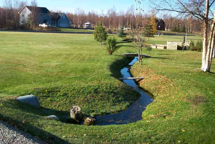
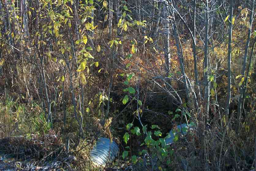
Site Comments: Downstream channelized through yard, lawn, down to waterline.
arrow to the right of the survey date below to choose a different report for this site.
Survey MSCS1-CT142
Observers: Edward Weiss, Doug Hill
Overall Fish Passage Rating:
Tidal: No
Backwatered: No
Step Pools:
Construction Year:
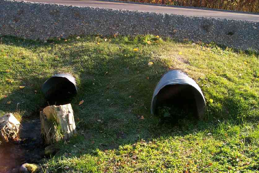
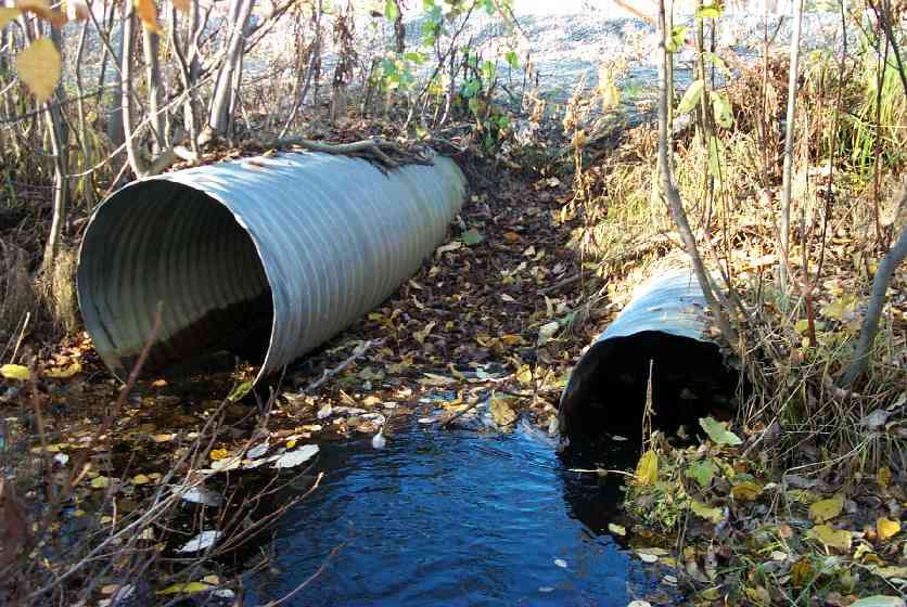
Comments: Dwnstrm channelized thru yard, lawn, down to waterline; Left Culv larger of 2 is overlflow trickling; No real channel below-flows thru lawn into main channel;land owner complains of icing/glaciering
Culvert Measurements
| ID: 1 | Structure Type: Circular pipe (Corrugated Metal) | Fish Passage Rating: | |||||||||||||||||||||||||||||||||||||||||
|
|
|
|||||||||||||||||||||||||||||||||||||||||
Culvert Observations:
|
|||||||||||||||||||||||||||||||||||||||||||
| ID: 2 | Structure Type: Circular pipe (Corrugated Metal) | Fish Passage Rating: | |||||||||||||||||||||||||||||||||||||||||
|
|
|
|||||||||||||||||||||||||||||||||||||||||
Culvert Observations:
|
|||||||||||||||||||||||||||||||||||||||||||
Stream Measurements
|
|
| Stream Width Type | Distance From Crossing (ft) |
Stream Width (ft) |
|---|---|---|
| Downstream ordinary high water | 50.0 | 3.00 |
| Downstream ordinary high water | 100.0 | 3.30 |
| Upstream ordinary high water | 50.0 | 4.00 |
| Upstream ordinary high water | 100.0 | 5.50 |
Elevations
| Locator ID | Culvert Number |
River Distance (ft)1 |
Distance From Crossing (ft)2 |
Relative Elevation (ft) |
|---|---|---|---|---|
| D/S Thalweg | 90.28 | |||
| D/S Thalweg | 90.33 | |||
| U/S Thalweg | 90.94 | |||
| U/S Thalweg | 91.24 | |||
| Outlet Culvert Top | 1 | 92.85 | ||
| Inlet Culvert Top | 1 | 92.86 | ||
| Outlet Culvert Top | 2 | 93.51 | ||
| Inlet Culvert Top | 2 | 93.97 | ||
| Outlet Invert | 1 | 0.00 | 0.0 | 90.87 |
| Outlet Thalweg | 1 | 0.00 | 0.0 | 90.91 |
| Outlet Invert | 2 | 0.00 | 0.0 | 91.41 |
| Outlet Thalweg | 2 | 0.00 | 0.0 | 91.41 |
| Road Elev | 25.50 | 95.66 | ||
| Road Elev | 25.50 | 95.68 | ||
| Inlet Culvert Invert | 2 | 51.00 | 0.0 | 91.40 |
| Inlet Thalweg | 2 | 51.00 | 0.0 | 91.40 |
| Inlet Culvert Invert | 1 | 51.00 | 0.0 | 90.78 |
| Inlet Thalweg | 1 | 51.00 | 0.0 | 90.78 |
Notes:
- River distance is measured continuously throughout the survey reach along the thalweg of the stream.
- Measured from each end of the crossing along the thalweg of the stream.
Fish Sampling Efforts
| Gear Type: Minnow Trap (A) | Trap Duration(h): 1 | |
Fish Observations
| Species: juvenile/adult Dolly Varden | Life History: Unknown | ||
| Total Fish Observed: 1 | Fish Measured: 1 | Fork Lengths (mm) Min: 91 Max: 91 Mean: 91 | |
| Collected/Observed by Gear Type: Upstream Minnow Trap (1) | |||
| Species: juvenile coho salmon | Life History: Anadromous | ||
| Total Fish Observed: 9 | Fish Measured: 5 | Fork Lengths (mm) Min: 59 Max: 100 Mean: 87 | |
| Collected/Observed by Gear Type: Upstream Minnow Trap (9) | |||
Photos
Questions or comments about this report can be directed to dfg.dsf.webmaster@alaska.gov