Fish Count Data Search
|
Location: Buskin River |
The selected years are color-coded in the graphs below:
|
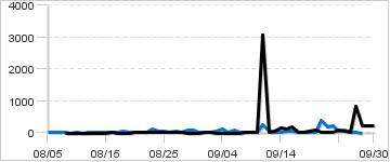
Daily Counts
|
Cumulative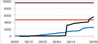
|
|
Description: Buskin weir for sockeye escapement is located at the outlet of the Buskin Lake between May 25 thru August 15. A second weir is installed down river on August 15th to just above bridge #2, where it remains until September 30 to enumerate coho salmon.
Biological Escapement Goal for Coho:
4,700 - 9,600
(Graphed above)
|
|
|
Contact:
Assistant Area Manager, | |
57 records returned for the years selected. Dashes indicate days with no count.
[Export results in Excel format or JSON format]
| Date 2017 |
Count 2017 |
Cumulative 2017 |
Cumulative 2016 |
Notes for 2017 |
|---|---|---|---|---|
| Sep-30 | 216 | 5,559 | 2,488 | |
| Sep-29 | 216 | 5,343 | 2,488 | |
| Sep-28 | 216 | 5,127 | 2,488 | |
| Sep-27 | 846 | 4,911 | 2,488 | |
| Sep-26 | 2 | 4,065 | 2,461 | |
| Sep-25 | 40 | 4,063 | 2,451 | |
| Sep-24 | 70 | 4,023 | 2,360 | |
| Sep-23 | 24 | 3,953 | 2,325 | |
| Sep-22 | 25 | 3,929 | 2,114 | |
| Sep-21 | 15 | 3,904 | 1,934 | water level 1.6 |
| Sep-20 | 91 | 3,889 | 1,551 | water level 1.5 |
| Sep-19 | 67 | 3,798 | 1,530 | water level 1.6 |
| Sep-18 | 13 | 3,731 | 1,511 | |
| Sep-17 | 25 | 3,718 | 1,507 | |
| Sep-16 | 178 | 3,693 | 1,483 | water level 1.5 |
| Sep-15 | 105 | 3,515 | 1,441 | water level 1.5 |
| Sep-14 | 160 | 3,410 | 1,377 | water level 1.5 |
| Sep-13 | 46 | 3,250 | 1,360 | water level 1.5 |
| Sep-12 | 33 | 3,204 | 1,329 | water level 1.5 |
| Sep-11 | 3,052 | 3,171 | 1,285 | water level 1.6; estimate added from aerial and float surveys |
| Sep-10 | 5 | 119 | 1,017 | |
| Sep-09 | 20 | 114 | 1,007 | Water level 1.75 |
| Sep-08 | 30 | 94 | 992 | weir back in |
| Sep-07 | 0 | 64 | 975 | |
| Sep-06 | 0 | 64 | 970 | |
| Sep-05 | 0 | 64 | 883 | weir flooded |
| Sep-04 | 0 | 64 | 863 | |
| Sep-03 | 0 | 64 | 745 | |
| Sep-02 | 1 | 64 | 707 | |
| Sep-01 | 2 | 63 | 687 | |
| Aug-31 | 0 | 61 | 669 | weir flooded |
| Aug-30 | 0 | 61 | 660 | weir flooded |
| Aug-29 | 0 | 61 | 574 | Weir flooded |
| Aug-28 | 7 | 61 | 487 | |
| Aug-27 | 12 | 54 | 480 | |
| Aug-26 | 17 | 42 | 418 | |
| Aug-25 | 12 | 25 | 410 | Water level 1.2 ft |
| Aug-24 | 4 | 13 | 358 | Water level 1.2 ft |
| Aug-23 | 1 | 9 | 324 | |
| Aug-22 | 4 | 8 | 220 | Water level 1.3 ft |
| Aug-21 | 2 | 4 | 189 | Water level 1.4 feet |
| Aug-20 | 1 | 2 | 160 | |
| Aug-19 | 0 | 1 | 137 | |
| Aug-18 | 0 | 1 | 121 | |
| Aug-17 | 0 | 1 | 86 | |
| Aug-16 | 1 | 1 | 69 | |
| Aug-15 | 0 | 0 | 63 | Weir out |
| Aug-14 | 0 | 0 | 51 | Weir out |
| Aug-13 | 0 | 0 | 21 | Weir out |
| Aug-12 | 0 | 0 | 18 | Weir out |
| Aug-11 | 0 | 0 | 16 | Weir out |
| Aug-10 | 0 | 0 | 16 | Weir out |
| Aug-09 | 0 | 0 | 12 | Weir out |
| Aug-08 | 0 | 0 | 12 | Weir out |
| Aug-07 | - | - | 10 | |
| Aug-06 | - | - | 3 | |
| Aug-05 | - | - | 2 |