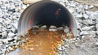
Fish Passage Site 20300976
Coordinates (dec. deg.): 60.55966°, -151.27333°
Legal Description: S005N011W06
Region: South Central
Road Name: Kenai Spur Road
Datum: NAD83
Quad Name / ITM: Kenai C-4
AWC Stream #: 244-30-10010-2001
Stream Name: Unnamed
Elevation:
Site Comments: None
arrow to the right of the survey date below to choose a different report for this site.
Survey KEN17-KSH01
Observers: Elise Idle, Maggie Schaffer, Jeff Sires
Overall Fish Passage Rating:
Tidal: No
Backwatered: No
Step Pools: Yes
Construction Year: 2016
Site Observations:
- Beaver Activity
- Debris Flow
Comments: Training site for culvert assessments. Site has been replaced with a fish passage culvert. Site has some construction problems. Culvert set within 1% of stream gradient and still has complete bedload coverage and is embedded, however badly constructed steps inside of culvert are causing fish passage issues at lower flows. Upstream step near inlet is collecting debris and causing a fish passage issue. Site rated Gray until issues can be fixed.
Culvert Measurements
| ID: 1 | Structure Type: Circular pipe (Corrugated steel) | Fish Passage Rating: | ||||||||||||||||||||||||||||||||||||||||||
|
|
|
||||||||||||||||||||||||||||||||||||||||||
Comments: 8 constructed step pools through at the barrel of the culvert. Many of the steps were installed incorrectly and are causing fish passage issues at lower flows. The upper steps are collecting large amounts of debris from the upstream wetland and backing up water. |
||||||||||||||||||||||||||||||||||||||||||||
Culvert Observations:
|
||||||||||||||||||||||||||||||||||||||||||||
Stream Measurements
|
|
No stream width data available.
Elevations
No elevation data available.
Fish Sampling Efforts
No fish sampling occurred during this survey.
Fish Observations
No fish observations occurred during this survey.
Questions or comments about this report can be directed to dfg.dsf.webmaster@alaska.gov


