Fish Passage Site 10303468
Coordinates (dec. deg.): 58.38546°, -134.74379°
Legal Description: C040S065E19
Region: Southeast
Road Name: Glacier Highway
Datum: NAD83
Quad Name / ITM: Juneau B-3
AWC Stream #:
Stream Name: Unnamed Tributary to Campground Creek
Elevation:
Site Comments: None
Survey UPDATE-GLU01
Project Supervisor: Gillian O'Doherty, ADFG
Observers: Mark Eisenman
Overall Fish Passage Rating:
Tidal:
Backwatered:
Step Pools:
Construction Year:
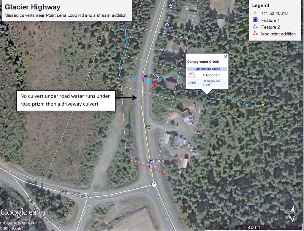
Comments: Culvert was missed during the 2011-12 surveys. Stream flows through culvert under Glacier Highway to the west then flows north about 300 feet before flowing under the road where there is no culvert and emerges on the other side of the road to the east and flows through a driveway culvert in a drainage ditch and then flows into Campground Creek, AWC 111-50-10310. Campground creek flows west at the confluence then passes back under the Glacier Highway and eventually passes though sites 10302216 on Point Lena Loop Rd and then though site 10302217 on the campground road. During visit it was noticed that at high water events the area on the west side of the highway floods and overtops the embankment north and the creek flows directly into Campground creek on the west side of the highway.
Culvert Measurements
| ID: 1 | Structure Type:N/A | Fish Passage Rating: | |||||||||||||||||||||||||||||||||||||||||
|
|
|
|||||||||||||||||||||||||||||||||||||||||
Stream Measurements
|
|
No stream width data available.
Elevations
No elevation data available.
Fish Sampling Efforts
No fish sampling occurred during this survey.
Fish Observations
No fish observations occurred during this survey.
Photos
Questions or comments about this report can be directed to dfg.dsf.webmaster@alaska.gov