Fish Count Data Search
|
Location: Little Susitna |
The selected years are color-coded in the graphs below:
|
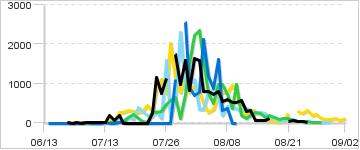
Daily Counts
|
Cumulative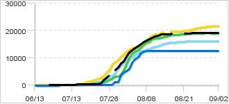
|
|
Description: Little Su weir:The Little Susitna weir is located at river mile 32.5, approximately 4 miles upstream of the public use facility off Point MacKenzie Rd. Escapement is primarily monitored using a resistance board weir. An underwater video system is installed within the weir and motion-detected fish passage is recorded during nighttime hours and at times when the river is heavily glaciated. The river is a strong producer of coho, chum, and pink salmon and a moderate producer of king salmon. Salmon fishing is allowed from its mouth upstream to the Parks Highway.
Sustainable Escapement Goal for Chinook:
2,100 - 4,300
|
|
|
Contact:
Area Management Biologist, |
|
65 records returned for the years selected. Dashes indicate days with no count.
[Export results in Excel format or JSON format]
| Date 2023 |
Count 2023 |
Cumulative 2023 |
Cumulative 2022 |
Cumulative 2021 |
Cumulative 2020 |
Cumulative 2019 |
Notes for 2023 |
|---|---|---|---|---|---|---|---|
| Sep-02 | - | 19,110 | 12,605 | 18,952 | 16,145 | 21,806 | |
| Sep-01 | - | 19,110 | 12,605 | 18,952 | 16,145 | 21,696 | |
| Aug-31 | - | 19,110 | 12,605 | 18,952 | 16,145 | 21,622 | |
| Aug-30 | - | 19,110 | 12,605 | 18,952 | 16,145 | 21,496 | |
| Aug-29 | - | 19,110 | 12,605 | - | 16,144 | 21,398 | |
| Aug-28 | - | 19,110 | 12,605 | 18,952 | 16,137 | 21,302 | |
| Aug-27 | - | 19,110 | 12,605 | 18,949 | 16,123 | 21,188 | |
| Aug-26 | - | 19,110 | 12,605 | 18,941 | 16,114 | 20,967 | |
| Aug-25 | 16 | 19,110 | 12,605 | 18,916 | 16,102 | 20,788 | |
| Aug-24 | 36 | 19,094 | 12,605 | 18,882 | 16,090 | 20,464 | |
| Aug-23 | 46 | 19,058 | 12,605 | 18,854 | 16,051 | 20,215 | |
| Aug-22 | 67 | 19,012 | 12,605 | 18,827 | 16,017 | 19,920 | |
| Aug-21 | 50 | 18,945 | 12,605 | 18,766 | 15,938 | 19,920 | |
| Aug-20 | - | - | 12,605 | 18,655 | 15,855 | 19,676 | |
| Aug-19 | - | - | 12,605 | 18,536 | 15,802 | 19,630 | |
| Aug-18 | - | - | 12,605 | 18,440 | 15,757 | 19,620 | |
| Aug-17 | 104 | 18,895 | 12,605 | 18,310 | 15,655 | 19,586 | |
| Aug-16 | 67 | 18,791 | 12,605 | 18,113 | 15,533 | 19,544 | |
| Aug-15 | 72 | 18,724 | 12,605 | 17,973 | 15,302 | - | |
| Aug-14 | 69 | 18,652 | 12,605 | 17,731 | 15,031 | 19,439 | |
| Aug-13 | 312 | 18,583 | 12,605 | 17,458 | 14,780 | 19,116 | |
| Aug-12 | 281 | 18,271 | 12,605 | 17,275 | 14,465 | 18,798 | |
| Aug-11 | 581 | 17,990 | 12,605 | 17,151 | 14,103 | 18,592 | |
| Aug-10 | 528 | 17,409 | 12,605 | 16,962 | 13,838 | 18,300 | |
| Aug-09 | 523 | 16,881 | 12,605 | 15,976 | 13,471 | 17,507 | |
| Aug-08 | 588 | 16,358 | 12,605 | 15,611 | 13,088 | 16,543 | |
| Aug-07 | 534 | 15,770 | 12,226 | 14,883 | 12,675 | 15,761 | |
| Aug-06 | 813 | 15,236 | 11,897 | 13,897 | 12,483 | 14,979 | |
| Aug-05 | 719 | 14,423 | 10,288 | 12,917 | 11,845 | 14,221 | |
| Aug-04 | 797 | 13,704 | 9,414 | 12,418 | 11,008 | 13,878 | |
| Aug-03 | 802 | 12,907 | 8,224 | 11,676 | 10,199 | 13,623 | |
| Aug-02 | 1,588 | 12,105 | 6,089 | 10,070 | 9,849 | 13,132 | |
| Aug-01 | 1,648 | 10,517 | 5,314 | 7,718 | 9,500 | 12,321 | Water level 3.34 |
| Jul-31 | 837 | 8,869 | 4,620 | 5,503 | 8,386 | 11,386 | |
| Jul-30 | 1,585 | 8,032 | 3,716 | 4,025 | 7,323 | 10,613 | |
| Jul-29 | 983 | 6,447 | 1,149 | 3,290 | 6,498 | 9,282 | |
| Jul-28 | 1,748 | 5,464 | 1,149 | 3,164 | 4,200 | 8,512 | |
| Jul-27 | - | - | 38 | 2,523 | 3,532 | 7,379 | |
| Jul-26 | 1,131 | 3,716 | 38 | 1,939 | 3,391 | 5,362 | water level 3.8 |
| Jul-25 | 747 | 2,585 | 38 | 1,471 | 1,795 | 4,609 | |
| Jul-24 | 1,147 | 1,838 | 38 | 1,178 | 1,683 | 3,502 | water level 4.1 |
| Jul-23 | 229 | 691 | 38 | 912 | 1,389 | 2,618 | water level 4.3 |
| Jul-22 | 0 | 462 | 38 | 626 | 1,214 | 2,330 | weir flooded |
| Jul-21 | 0 | 462 | 38 | 606 | 1,015 | 1,888 | weir flooded |
| Jul-20 | 0 | 462 | 38 | 573 | 733 | 1,597 | Weir flooded |
| Jul-19 | 0 | 462 | 38 | 454 | 333 | 1,338 | Weir flooded |
| Jul-18 | 0 | 462 | 38 | 231 | 244 | 1,053 | weir flooded |
| Jul-17 | 0 | 462 | 38 | 90 | 102 | 742 | Weir flooded |
| Jul-16 | 185 | 462 | 24 | 49 | 40 | 463 | |
| Jul-15 | 52 | 277 | 4 | 24 | 7 | 187 | |
| Jul-14 | 200 | 225 | 4 | 7 | 7 | 130 | |
| Jul-13 | 10 | 25 | 4 | 2 | 7 | 31 | |
| Jul-12 | 9 | 15 | 3 | 2 | 7 | 20 | |
| Jul-11 | 1 | 6 | 3 | 2 | 7 | 18 | |
| Jul-10 | 2 | 5 | 3 | 2 | 7 | 17 | |
| Jul-09 | 1 | 3 | 3 | 2 | 7 | 13 | |
| Jul-08 | 0 | 2 | 0 | 2 | 0 | 11 | |
| Jul-07 | 1 | 2 | 0 | 0 | 0 | 8 | |
| Jul-06 | 0 | 1 | 0 | 0 | 0 | 2 | |
| Jul-05 | 1 | 1 | 0 | 0 | 0 | 2 | |
| Jul-04 | - | - | 0 | 0 | 0 | 1 | |
| Jul-03 | - | - | 0 | 0 | 0 | 1 | |
| Jul-02 | - | - | 0 | 0 | 0 | 1 | |
| Jul-01 | - | - | 0 | 0 | 0 | 1 | |
| Jun-13 | - | - | 0 | 0 | 0 | 1 |